HOME /COMMS & RADIO /NOAA WEATHER RADIO — 1,035 TRANSMITTERS | FREE STATUS-CODED KMZ FOR ATAK, TAK AWARE & GOOGLE EARTH
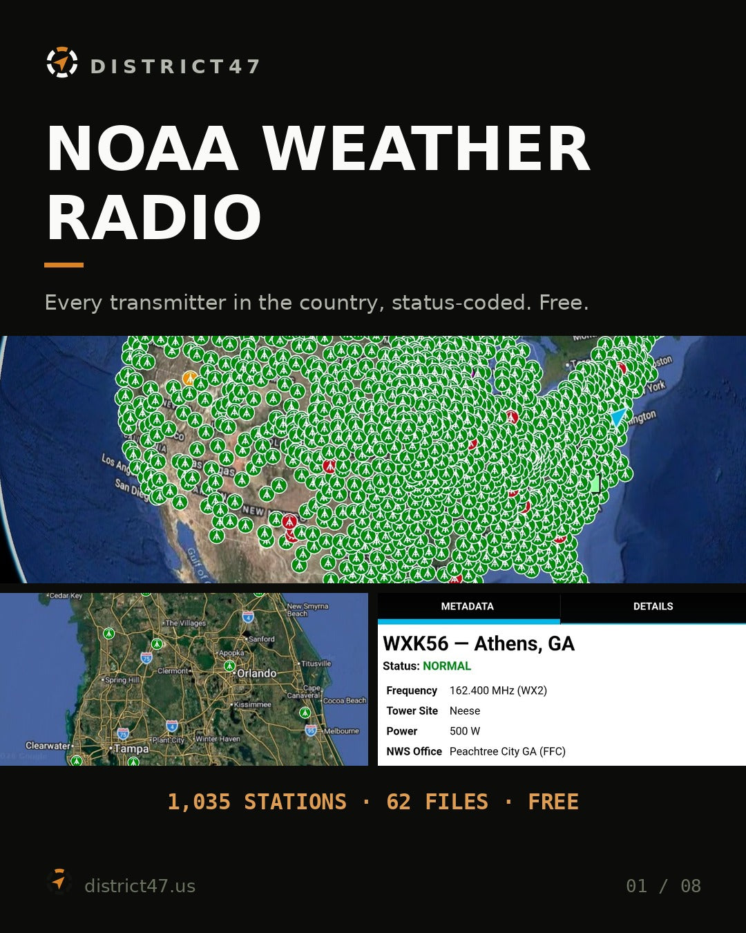
NOAA Weather Radio — 1,035 Transmitters | Free Status-Coded KMZ for ATAK, TAK Aware & Google Earth
SKU: D47-NWR-US
Every NOAA Weather Radio transmitter in the country. Free.
1,035 NOAA Weather Radio transmitters across all 50 states and the U.S. territories, each pin carrying its callsign, broadcast frequency, WX channel, transmitter power, tower site, forecast office and operational status.
It ships as 62 KMZ files — one national, 7 regional and 54 by state or territory — plus a master CSV for spreadsheet and GIS work.
Free, no account needed. If it saves you one session of squinting at a coverage map, it did its job.
Reference use only — please read
This is a snapshot of a station inventory, not a live status feed and not an alerting system.
- Status changes. Transmitters go down for maintenance, storms and funding. A station marked normal here can be off the air today.
- No SAME or FIPS alerting data. This maps where transmitters are. It does not tell you which counties a station alerts for, and it is not a substitute for programming your receiver correctly.
- Coverage is not drawn. A pin is a transmitter location. Terrain, power and your antenna decide whether you can actually hear it — a 1000 W station behind a ridge may be useless while a 300 W station in the open is fine.
- Source labeling anomalies were preserved. A handful of records carry a state field that disagrees with their coordinates or forecast office. Those values were left as supplied rather than silently corrected, so you can see them rather than trust a quiet fix.
- For anything that matters, confirm with NOAA. Current status, frequency, coverage and SAME alerting belong to the National Weather Service.
How the color coding works
Icon color is the operational status recorded in the source inventory.
GREEN — normal
1,004 transmitters reported operating normally.
AMBER — degraded
17 transmitters reported operating in a degraded condition.
RED — out of service
14 transmitters reported off the air.
Station folders are also separated by status, so you can toggle a category off entirely. Icons are embedded in every KMZ — no icon server, no broken pins, no fetch when you're off-grid.
Frequencies and channels
NOAA Weather Radio uses seven VHF frequencies. Every card shows both the MHz value and the WX designation, so it reads the way your radio is labeled.
- WX1 — 162.550 MHz
- WX2 — 162.400 MHz
- WX3 — 162.475 MHz
- WX4 — 162.425 MHz
- WX5 — 162.450 MHz
- WX6 — 162.500 MHz
- WX7 — 162.525 MHz
Inside every station card
- Callsign — e.g. KIH63, WXK56, WXL40
- City and state or territory
- Frequency in MHz and its WX channel
- Tower site name and transmitter power in watts
- NWS forecast office responsible for the station
- Operational status and coordinates
- Public internet audio feeds, where the source lists them — useful when you have data but no receiver
File structure
- USA_NOAA_Weather_Radio_All_Stations.kmz — the national file, organized by state and status
- regional_kmz/ — 7 files: Northeast 80, Southeast 251, Midwest 312, Southwest 123, Northwest 170, Pacific 94, Territories 5
- state_kmz/ — 54 files, one per state or territory code
- NOAA_NWR_Master_Stations.csv — the full tabular dataset
- assets/ — the tower icons, also embedded in each KMZ
Texas carries 78 transmitters, Alaska 52, Kentucky 40, Minnesota 37, California 35. Rhode Island, Guam, the Virgin Islands and the Northern Marianas carry one each.
Compatibility
- ATAK / CivTAK / iTAK / WinTAK: import directly or drop into Data Packages
- TAK Aware (iPhone)
- Google Earth Pro (desktop) and Google Earth Web
- QGIS, ArcGIS and other KML/KMZ-capable GIS software
- Any application reading standard OGC KML 2.2
Fully functional offline once loaded. The audio-feed links on each card are the only part that needs a connection, and only if you choose to open one.
Who it's for
- Anyone programming a weather radio or a scanner who wants the nearest transmitter and its channel without hunting through a website
- Amateur radio and ARES/RACES operators building a comms plan for a county or a region
- Emergency managers checking which transmitters cover an area and which are degraded
- Preparedness-minded households who want the local frequency written down before they need it
- Travelers and overlanders who want the channel for wherever they're heading, offline
Keep the free files free
This one costs nothing and always will. The free packages are paid for by people who chip in after downloading one — if this saved you time, there's a donation page. Any amount, no obligation, and the files stay free either way.
Sources & methodology
Built from the national NOAA Weather Radio station inventory. Records were parsed into structured fields and each broadcast frequency mapped to its standard WX1–WX7 channel designation. Coordinates came with the source, so no geocoding was involved. Station descriptions were rendered into map panels carrying callsign, frequency, channel, tower site, power, forecast office, coordinates, region, status and any listed audio feeds. State and territory files were generated individually; regional files contain a folder per state, each subdivided by status. Icons are embedded so every file stays portable.
Where the source inventory contained apparent state-labeling anomalies, the original values were preserved rather than reassigned.
Data attribution
Station data originates with NOAA and the National Weather Service. Official reference: weather.gov/nwr. Audio feed URLs, where present, belong to third-party operators.
District47 is not affiliated with, endorsed by, or sponsored by NOAA, the National Weather Service, or the U.S. Government. This package adds the channel mapping, status styling, folder structure, embedded icons and the state, regional and national builds on top of the source inventory.
Terms
Free for personal and organizational use. Please link to district47.us rather than rehosting the files, so people get current versions. Provided as-is with no warranty of accuracy, completeness, or fitness for any particular purpose. Not a substitute for official NOAA/NWS information or for a correctly programmed receiver.