HOME /PLUGINS /FUELTAK — 293,827 SITES OFFLINE | ATAK PLUGIN WITH FUEL TYPES, TANK CAPACITY & WHO CAN BUY THERE


FuelTAK — 293,827 Sites Offline | ATAK Plugin with Fuel Types, Tank Capacity & Who Can Buy There
SKU: D47-FUELTAK
When the pumps are down or you're somewhere new, ATAK can show you a gas station, but not what's stored there, how much the tanks hold, or whether anyone would sell to you. The records exist: EPA and the states register fuel tanks, the FAA lists which airfields sell fuel, EIA lists every refinery. They're spread across dozens of government websites that don't work without a signal. FuelTAK puts 293,827 sites on your ATAK map, says who can buy at each one, and works in airplane mode.
WHY IT'S IN THE SHOP
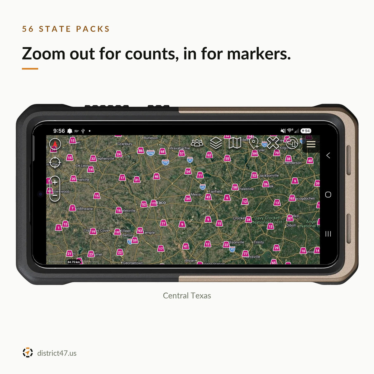
A fuel KMZ is frozen the day you load it, and a state's worth of sites in one file can stall ATAK. FuelTAK is a plugin plus a District47 server. The server pulls federal records and tank registries from 39 states and DC, merges the same site listed twice, joins fuels and capacity to each site, rates how well the records agree, and splits it all into one small pack per state. Your phone downloads your states once and reads them offline.

WHAT'S INSIDE
- 293,827 sites in 56 states and territories. 146,708 retail stations, 2,669 truck stops, 5,708 aviation fuel sites, 2,605 marine docks, 2,663 terminals and tank farms, 130 refineries, 210 petroleum ports, plus propane, alternative fuels, fleets, utilities and emergency generator fuel.
- 14 fuel types. Gasoline, diesel, kerosene, heating oil, avgas, jet fuel, propane, CNG, LNG, E85, biodiesel, renewable diesel, hydrogen and other petroleum. Filter by any of them, or switch to diesel only.
- Tanks and registered capacity. Tank counts, gallons by fuel and the oldest tank, where the records report them. A corner dot on each marker shows the storage size at a glance.
- Who can buy there. Every site is public, restricted, private or unknown. Restricted and private sites wear a red no-entry badge. Public and restricted sites show by default; private sites and unknown access are one tap away.
- Works with no signal. One pack per state, about 340 KB for a typical state and 3.5 MB for Texas, the largest. The map, cards and Nearby all work in airplane mode.
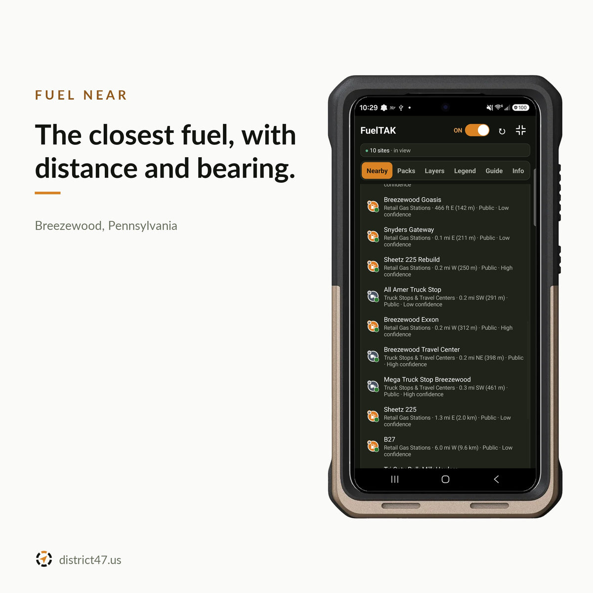
- Fuel near you. From your position, the map center or a point you pick: the closest sites with distance and bearing, filtered by fuel, access and confidence.
- A confidence level on every site. How well the records agree and how recent they are, shown on the card.
- Navigate with NavTAK. A button on the card hands the site to NavTAK, if you have a current version installed.
- Range and generator calculators. How far your gallons will go, how long a generator will run, and general fuel notes, all offline.
- Saved sites and notes. Save any site, write what you found, and export them all to KML.
- Updates when there's news. A notification when newer data is ready, checked once a day. Wi-Fi only by default.

HOW ACCESS WORKS
A place that holds fuel isn't always a place you can buy it. A station sells to anyone. A school bus yard, a hospital generator or a refinery does not. FuelTAK shows those restricted sites because they hold fuel, and marks them with a red no-entry badge so you can tell at a glance. One tap on the Layers tab hides them.
Access follows the kind of site and what the source says, not a visit to the gate. It can be wrong in either direction. A public-use airfield reads Restricted because the ramp is controlled, even though pilots buy fuel there. Read the card, and confirm locally.


STATE COVERAGE VARIES
Most packs combine federal data with that state's own tank registry where one is usable. Ten states stay on federal data because no usable bulk registry was found. Two more have less than you might expect:
- Montana (1,347 sites): federal EPA and other national data only. Montana's state tank registry isn't included, so sites there show less fuel-type and tank-capacity detail, and sites only the state lists are missing.
- Kansas (2,763 sites): Kansas's state registry only adds status, fuel and capacity to sites EPA already names. It doesn't add new sites, so about 19,000 aboveground tank records in the state's list aren't shown.
REQUIREMENTS
- ATAK-CIV 5.6 on Android
- APK of 1.2 MB, plus 2 KB to 3.5 MB of download per state you install
- A connection once, to download your state packs; none after that
- GPS for "My position"; everything else works from the map center
HOW TO INSTALL
- Check out. The download link arrives by email.
- Copy the APK to your Android phone and install it.
- Open ATAK and tap OK when it offers to load FuelTAK.
- Open FuelTAK from the ATAK tools menu, read and accept the terms, and download the pack for your state.
FIELD NOTES
FuelTAK does not know whether a site is open, has fuel, has power to pump it, or will sell it to you. Storage figures are registered tank capacity, not what's in the tank today. Most tank records are from 2018 to 2021, and stations open and close. 2,798 sites could not be placed by any address search; they stay off by default, and if you turn them on they appear as estimated areas, not locations. The total also includes 1,913 truck parking and rest areas that have no fuel.
The "Report what you see" button on a card keeps your report on your phone for now: sharing reports with other users isn't open yet. "Report wrong data" reaches District47 today.
Your position stays on the phone: nearest fuel and distances are worked out on the device. It's only sent if you turn on "Include my position" in a problem report. Packs download from data.district47.dev, and as with any connection, that includes your IP address. The full terms are in the plugin's Info tab.
Already have the Fuel Intel KMZ? FuelTAK covers the same ground from public sources rebuilt site by site, and adds fuel filters, who can buy there, confidence levels, calculators and pack updates.
⚠ INFORMATIONAL USE ONLY
FuelTAK is a reference tool. A site on the map is not permission to enter it, buy from it, or take anything from it.
Its data comes from government sources that can be incomplete, out of date or wrong. A site may be closed, empty, secured or in the wrong place. Many listed sites are restricted or private. Bulk fuel sites can be dangerous: stay clear of them. Follow all laws and lawful orders, and use your own judgment.
To the fullest extent the law allows, District47 LLC and its owners are not liable for any injury, illness, death, loss or damage that comes from using FuelTAK or its data. By buying and using FuelTAK you accept its terms of use, shown in the plugin before first use.
Data: U.S. EPA (UST Finder, FRS), U.S. Department of Energy Alternative Fuels Data Center via the Bureau of Transportation Statistics, BTS National Transportation Atlas (truck parking, pipeline terminals, petroleum ports), FAA NASR, U.S. Energy Information Administration, and state tank registries. District47 is not affiliated with or endorsed by these agencies or by any business shown. ATAK is developed by the TAK Product Center; FuelTAK is an independent plugin.
DISTRICT47 · district47.us