District47
FREE: ALPR / Flock Camera ATAK Map — 106,000+ License Plate Readers Nationwide
FREE: ALPR / Flock Camera ATAK Map — 106,000+ License Plate Readers Nationwide
Couldn't load pickup availability
Know every camera watching the road — before you drive it.
This free KMZ overlay loads 106,000+ automated license plate readers (ALPRs) — Flock Safety, Motorola, Genetec, Leonardo, Axis and more — directly into ATAK, iTAK, WinTAK, Google Earth, or any TAK-compatible app. Fully offline once imported. No subscription, no account, no catch.
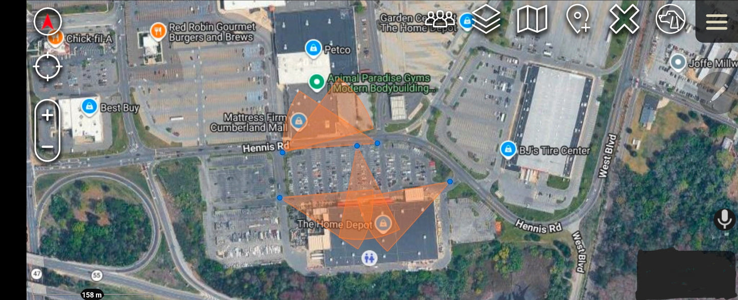
Built from public OpenStreetMap data and styled to feel familiar if you've ever used DeFlock — clean blue camera markers, with directional field-of-view cones showing exactly which way each reader is aimed.
📍 What's inside
- 106,283 ALPR camera locations across all 50 states
- 115,000+ directional FOV cones — see which direction each camera is pointing (98.6% of cameras include a verified heading)
- Tap any camera for brand, operator, mount type, surveillance zone, and OSM reference ID
- Zoom-aware rendering — markers thin out when zoomed wide, cones appear as you zoom in, so the map stays readable
📡 Works with
ATAK (Android) · iTAK (iPhone/iPad) · WinTAK · Google Earth · any KMZ-compatible mapping app
🛰️ Why it matters
Whether you're a privacy advocate, security researcher, journalist, off-grid traveler, or just someone who wants to understand the surveillance footprint of your daily commute — this overlay puts the full national picture in your pocket, offline and on your terms.
🗓️ Data current as of 6/25/2026. This package is updated regularly as new cameras are mapped — re-download anytime to stay current.
🙏 Credits & Attribution
Camera location data is sourced from OpenStreetMap contributors and the DeFlock community (deflock.org), whose crowd-sourced mapping effort makes nationwide ALPR transparency possible. This package is an independent, unaffiliated conversion of that public data into TAK-compatible format — full credit for the underlying dataset goes to the DeFlock project and OSM mappers.
Want to help improve this map? Contribute camera sightings at deflock.org.
📜 Data © OpenStreetMap contributors, licensed under the Open Database License (ODbL — opendatacommons.org/licenses/odbl). This derivative work is shared under the same license.
✅ 100% free. If this saves you time, check out the rest of the District47 ATAK data package collection — repeater maps, FEMA & tornado shelters, hospitals/fire/police, critical power infrastructure, POTA parks, and more. One-time files, no subscriptions, built by the same hands.
⚠️ Disclaimer: This data is provided for educational and informational purposes only, sourced from publicly available OpenStreetMap contributions. Camera locations are crowd-sourced and may be incomplete or outdated. Always do your own research and verify before relying on this information. Provided as-is, with no warranty.
Share