HOME /PLUGINS /AQUATAK — 721,349 WATER SOURCES OFFLINE | ATAK PLUGIN WITH EPA WATER QUALITY, TREATMENT CALCULATOR & PUBLIC LAND

AquaTAK — 721,349 Water Sources Offline | ATAK Plugin with EPA Water Quality, Treatment Calculator & Public Land
SKU: D47-AQUATAK
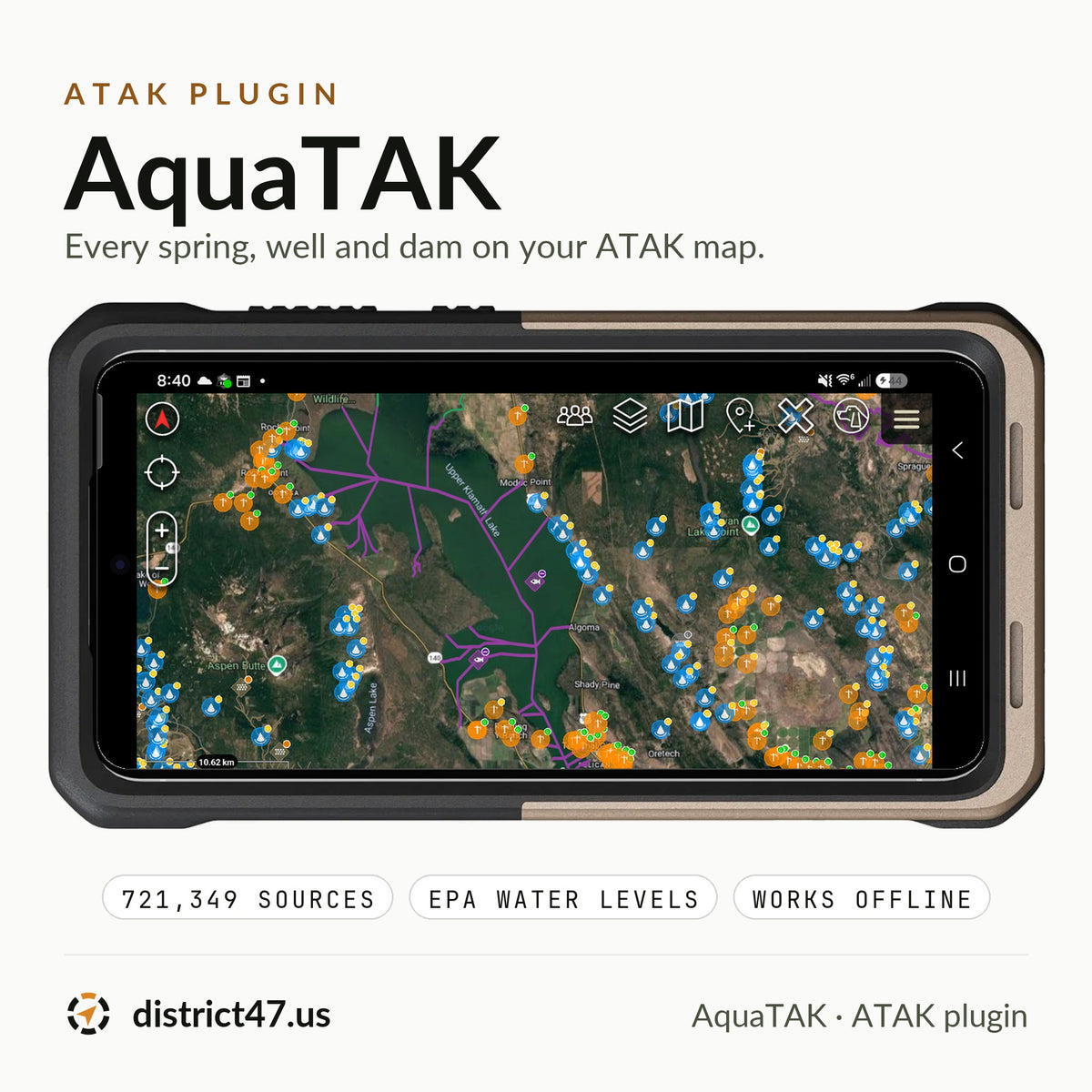
When you need water off the grid, ATAK can show you a blue line on the map, but not whether anything's in it, whether you can drink it, or whether you're allowed to get to it. The answers exist: USGS maps every well and spring, the Army Corps lists every dam, EPA keeps the record of which streams and lakes fail as drinking water and why. They're spread across a dozen federal websites that don't work without a signal. AquaTAK puts 721,349 water sources and 158,345 EPA-listed waters on your ATAK map, rates each listed water in plain words, and works in airplane mode.
WHY IT'S IN THE SHOP
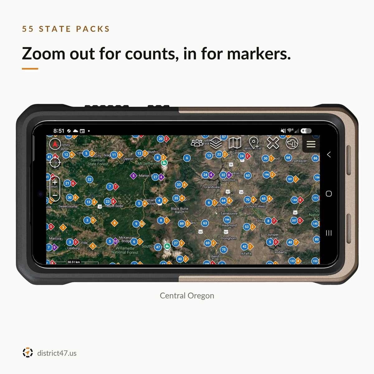
A water KMZ is out of date the week you load it, and a state's worth of springs and wells in one file is enough to stall ATAK. AquaTAK is a plugin plus a District47 server. Every week the server pulls seven public datasets, merges the same spring listed twice, rates every EPA listing, tags every source with the public land it's on, and splits it into one small pack per state. Your phone downloads your states once and reads them offline.

WHAT'S INSIDE
- 721,349 water sources, 55 states and territories. 455,835 groundwater wells and 164,050 springs (USGS), 92,198 dams (USACE National Inventory of Dams), 5,390 waterfalls (USGS NHD), Florida DEP springs. Every marker carries how well its position is known.
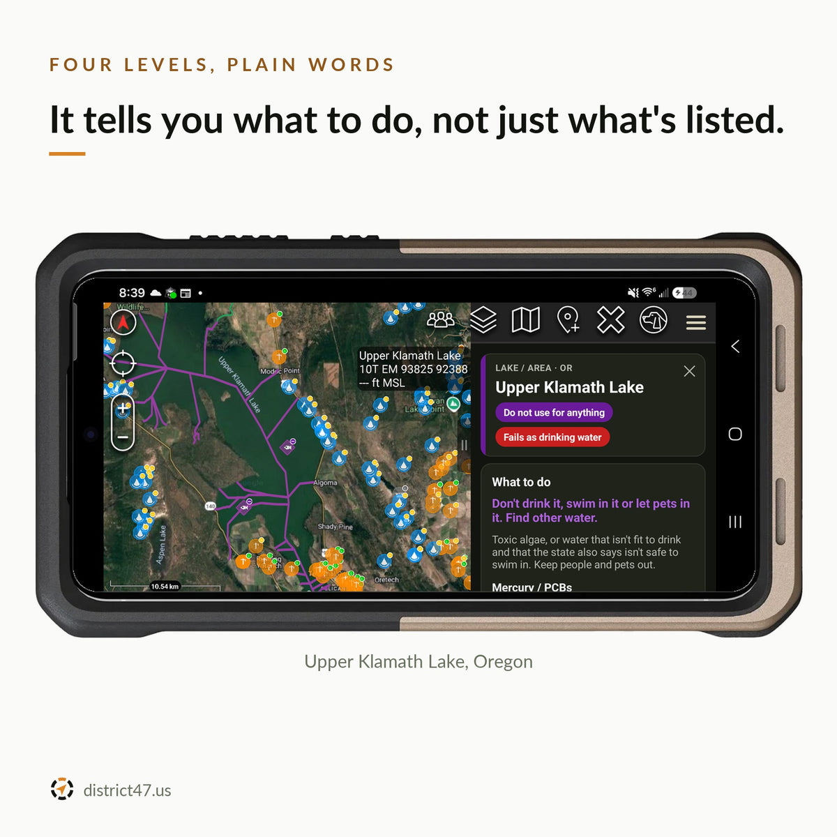
- 158,345 EPA-listed waters. Streams drawn as lines, lakes as outlines, points as diamonds, from EPA ATTAINS. Each one is rated on a four-level scale with what to do, its listed causes, the uses it fails, and a link to the state's own report.
- Works with no signal. One pack per state, 7 KB to 9.8 MB (a typical state is 1.4 MB). Map, cards, search and the treatment guide all work in airplane mode.
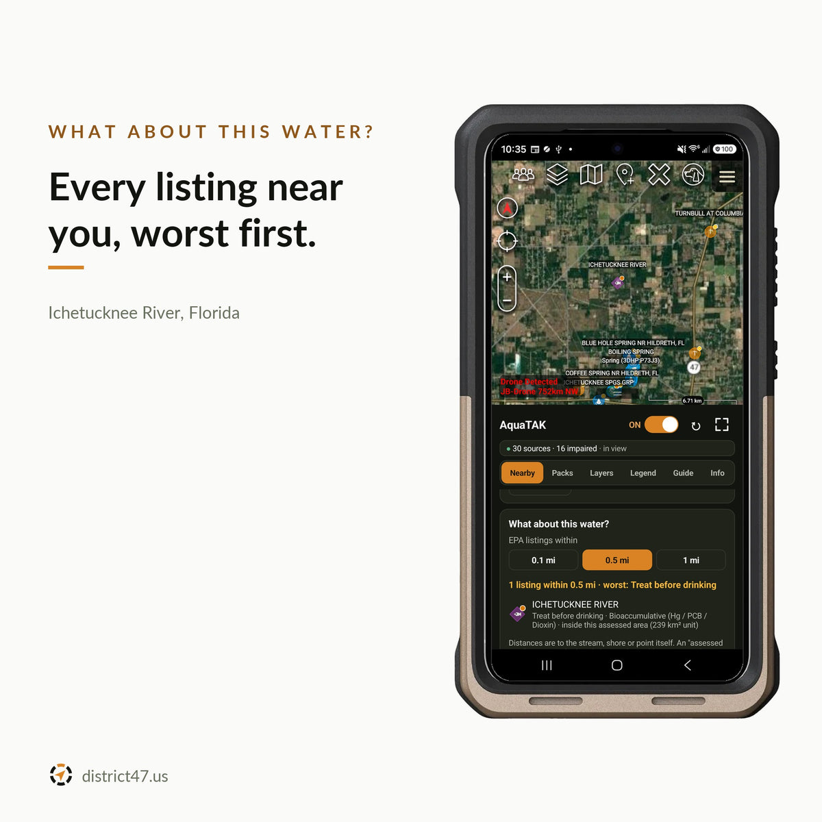
- Nearest water and "what about this water?" From your position, the map center or a point you pick: the closest sources with distance and bearing, and every listed water nearby, worst first.
- Public or private land. Each source is tagged from USGS PAD-US: the park, forest or refuge it's in, who manages it, and whether it's open to the public. Outside PAD-US, the card says it's likely private land: ask first.
- Conditions now. When you have a connection: the nearest USGS stream gauges against this day in past years, and the US Drought Monitor level here. A hint whether water is running.
- Field reports. Flowing, low, dry or looks bad: what other AquaTAK users saw, and when. Add your own in three taps; reports are anonymous.
- Dose calculator and timers. Bleach and iodine doses for your amount of water, a boil timer that goes to 3 minutes above 1,000 m, and a 30-minute disinfectant wait that runs with the menu closed.
- Saved waters and notes. Save any water, write what you found, and export them all to KML. Saves survive the weekly pack updates.
- Updates when there's news. A notification when newer data is ready, checked once a day. Wi-Fi only by default; optional automatic updates on Wi-Fi.

HOW THE LEVELS WORK
EPA lists a water as impaired when a state assesses it and it fails a use: drinking water, swimming, fish, aquatic life. A listing for sediment or bacteria means filter and treat it like any wild water. A listing for metals, PCBs or factory chemicals means filtering and boiling won't fix it: do not drink. Toxic algae, or water that's unfit to drink and unsafe to swim in, means keep people and pets out. AquaTAK reads every listing's causes and failed uses and gives the level in plain words, with the reasons underneath.
Most streams have never been assessed. "No listing found" is not "clean": treat every source, every time.


REQUIREMENTS
- ATAK-CIV 5.6 on Android
- APK under 1 MB, plus 7 KB to 9.8 MB of storage per state you install
- A connection once, to download your state packs; none after that
- GPS for "My position" and the high-altitude boil time; everything else works from the map center
HOW TO INSTALL
- Check out. The download link arrives by email.
- Copy the APK to your Android phone and install it.
- Open ATAK and tap OK when it offers to load AquaTAK.
- Open AquaTAK from the ATAK tools menu, read and accept the terms, and download the pack for your state.
FIELD NOTES
AquaTAK does not test water. Levels come from EPA listings, which cover only waters that states have assessed, and listings can be years old. A mapped well or spring may be dry, capped, or on private land. Conditions and field reports are hints, not promises: nobody checks field reports. Use your own judgment and treat every source.
Your position never leaves the phone: nearest water, distances and the boil time are all worked out on the device. Packs, conditions and reports download from data.district47.dev; a field report sends what you saw, the water's ID, a random ID for your copy of AquaTAK and, as with any connection, your IP address. The full terms are in the plugin's Info tab.
Already have the Water Intel KMZ? AquaTAK uses the same sources, adds the plain-language levels, public land, live conditions and the treatment tools, and updates itself every week.
⚠ INFORMATIONAL USE ONLY
AquaTAK is a reference tool. It does not test water and cannot tell you that any water is safe to drink, use or reach.
Its data comes from government sources that can be incomplete, out of date or wrong. A source on the map may be dry, contaminated, closed or on private land, and water with no listing has usually never been tested. Treat every source, every time, and use your own judgment.
To the fullest extent the law allows, District47 LLC and its owners are not liable for any injury, illness, loss or damage that comes from using AquaTAK or its data for anything other than information. By buying and using AquaTAK you accept its terms of use, shown in the plugin before first use.
Data: U.S. Geological Survey (NWIS, 3DHP, NHD, PAD-US 4, stream gauges), U.S. Army Corps of Engineers National Inventory of Dams, U.S. EPA ATTAINS, Florida Department of Environmental Protection, and the U.S. Drought Monitor (National Drought Mitigation Center, USDA, NOAA). District47 is not affiliated with or endorsed by these agencies. Treatment figures from U.S. EPA and CDC guidance. ATAK is developed by the TAK Product Center; AquaTAK is an independent plugin.
DISTRICT47 · district47.us