HOME /ATAK PLUGINS & DATA PACKAGES /U.S. RAIL NETWORK, STATIONS & YARDS — 239,395 PLACEMARKS | COLOR-CODED KMZ FOR ATAK, TAK AWARE & GOOGLE EARTH
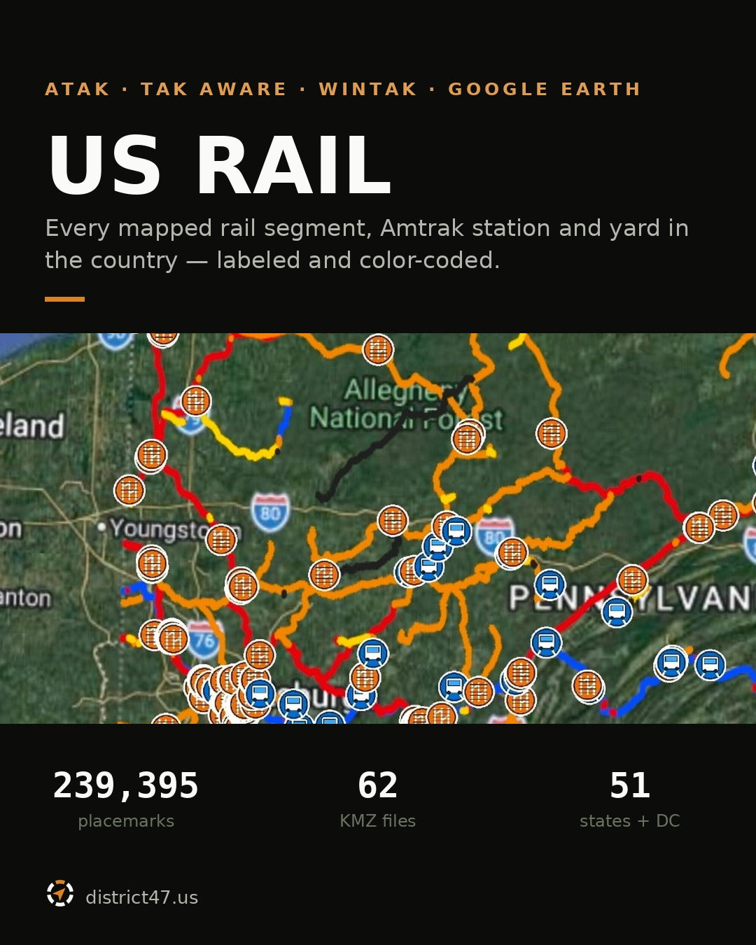
U.S. Rail Network, Stations & Yards — 239,395 Placemarks | Color-Coded KMZ for ATAK, TAK Aware & Google Earth
SKU: D47-RAIL-US
239,395 labeled rail placemarks. Every mapped segment, station and yard in the country.
A complete conversion of the federal rail network into KMZ: 235,700 rail segments, 1,015 Amtrak passenger stations and 2,680 rail yards — 239,395 placemarks across all 50 states and the District of Columbia.
Every segment is individually labeled and color-coded by class, so passenger route, Class I mainline, short line and industrial siding are distinguishable at a glance instead of being one undifferentiated web of lines.
It ships as 62 KMZ files: 51 by state or district, 11 by region. Regional files are kept under 5 MB so they actually load on a phone.
Reference use only — please read
This is an offline awareness dataset. It is not a timetable, not a navigation authorization, and not a statement that any corridor is safe or legally accessible.
- Railroad property is private property. Most active rights-of-way, yards, bridges and tunnels are privately owned. Do not enter or travel on them without authorization.
- Trains approach fast and quietly. Equipment moves without warning, and field conditions routinely differ from what any map shows.
- A yard pin is a centroid. It is calculated at the approximate center of the mapped yard, not at a gate, an entrance, or any public access point.
- Classification is attribute-driven. A segment may be labeled differently from local railroad usage where source fields are incomplete or several operators share rights.
- Segment counts are not track miles. A single route is split into many segments wherever ownership or attributes change. Parallel tracks multiply the count further.
- It's a snapshot. Rail line data carries a source-update date of 21 July 2026; the build was released September 2026. Ownership, operations, condition and passenger service all change after release.
- No basemap included. Placemarks and icons only. Load your own offline imagery or topo before you lose signal.
What is deliberately not in it
Listing what a dataset omits matters as much as listing what it holds. This baseline does not include grade crossings, bridges, tunnels, junctions or mileposts. It does not include medical facilities, emergency services, water, fuel or shelters. Former stations, intermodal terminals, maintenance facilities and abandoned corridors are held back for a future verified release rather than guessed at now.
The abandoned/inactive category exists in the symbology and is currently empty. Nothing was assigned to it without verification.
How the color coding works
Line color is the rail class, assigned from federal ownership and network attributes.
BLUE — passenger routes
18,232 segments where the passenger-use field is populated.
RED — Class I freight mainlines
132,833 segments with a Class I owner or trackage-rights operator.
ORANGE — regional and short lines
60,425 segments with a documented non-Class I owner.
YELLOW — industrial track and sidings
21,401 segments flagged industrial or carrying spur, siding or lead terms.
BLACK — unknown or unverified
2,809 segments where ownership and classification fields were insufficient. Marked honestly rather than assigned a guess.
GRAY — abandoned or inactive
Reserved. No features assigned in this baseline.
BLUE TRAIN ICON marks an Amtrak passenger station. ORANGE YARD ICON marks a rail yard.
Icons are embedded in every KMZ. No icon server, no broken pins, no fetch when you're off-grid.
Inside the labels and info panels
Segments are labeled by subdivision name where the source carries one, falling back to branch name, combined with the railroad owner where known. Where the federal source provides them, info panels carry:
- Federal segment identifiers
- Owner and operator codes, including trackage-rights operators
- Subdivision and branch names
- Passenger-service indicator and track counts
- Source metadata and confidence notes
Stations carry official station names and codes. Yards carry the mapped yard name and owner.
Attributes are preserved rather than invented — empty, null and placeholder values were cleaned out instead of being filled in with plausible-looking text.
File structure
Each file opens to state folders, then splits into Rail Network and Stops and Facilities, so lines and pins can be toggled independently.
- 51 state and district KMZ files — all 50 states plus DC
- 11 regional KMZ files — Northeast ×2, Southeast ×3, Midwest ×3, Southwest, Mountain West, Pacific
- This field guide — methodology, symbology, per-state counts and limitations
Large regions are split into numbered parts to stay under 5 MB. No state is ever divided across regional parts, and every state and district appears exactly once. Regional files duplicate state data for convenience; they do not add to the national count.
Density varies enormously. California holds 17,480 placemarks, Texas 16,756, Pennsylvania 14,982, Illinois 11,027. Hawaii holds 3. Alaska and South Dakota have no Amtrak stations at all.
Compatibility
- ATAK / CivTAK / iTAK / WinTAK: import directly or drop into Data Packages
- TAK Aware (iPhone)
- Google Earth Pro (desktop) and Google Earth Web
- QGIS, ArcGIS and other KML/KMZ-capable GIS software
- Any application reading standard OGC KML 2.2
Google My Maps note: regional files were held under 5 MB, but My Maps also applies feature and layer limits that vary by import workflow. If a dense regional file is rejected, import the matching state file instead.
Fully functional offline once loaded. Load only the state or region you need — a nationwide load of 239,395 placemarks will not perform on a handheld.
Who it's for
- Emergency managers and hazmat planners who need to know which corridor is a Class I mainline and which is a disused siding
- Search and rescue teams working corridors, yards and rail-adjacent terrain
- Amateur radio and ARES/RACES operators planning around rail infrastructure and rights-of-way
- Railfans and photographers who want labeled subdivisions offline instead of guessing from satellite imagery
- Logistics, utility and infrastructure staff who need rail context without a live GIS connection
Sources & methodology
- North American Rail Network Lines (FRA/BTS NTAD): rail geometry and operational attributes.
- NTAD Amtrak Stations: passenger-station locations and attributes.
- NTAD Rail Yards: rail-yard geometry and ownership.
What was done to it. Federal ArcGIS FeatureServer layers were queried by state and county FIPS with complete attributes in WGS 84, paginated to avoid record limits. Attributes were cleaned of null and placeholder values while preserving federal identifiers, owner and operator codes, subdivision and branch names, passenger indicators, track counts and source metadata. Each segment was classified deterministically from passenger indicators, Class I ownership and trackage-rights codes, industrial and siding terms, network flags, and the presence of a documented owner. Labels were built from subdivision, then branch, then owner. KML was generated with separate network and facilities folders and custom PNG icons embedded inside each archive.
Validation. Every ZIP was integrity-tested, every KML parsed, every placemark confirmed to carry geometry and a label, style references and embedded icons verified, feature counts reconciled, and the sub-5 MB regional target enforced.
Data attribution
Source data is public U.S. Department of Transportation material distributed by the Federal Railroad Administration and the Bureau of Transportation Statistics through the National Transportation Atlas Database. On top of it this product adds the classification scheme and color coding, the label construction, the folder hierarchy, embedded offline icons, the state and regional packaging, and the field guide.
District47 is not affiliated with, endorsed by, or sponsored by the FRA, BTS, Amtrak, or any railroad. For authoritative rail network data and program context, go to the FRA's maps and GIS resources.
Terms
Single-user license for personal reference and planning. Redistribution, resale or repackaging of these files is not permitted. Sold as-is with no warranty of accuracy, completeness, or fitness for any particular purpose. Not a substitute for railroad authorization, current operational information, or your own safety judgment around rail infrastructure.